Weather Alert in Illinois
Severe Thunderstorm Warning issued April 29 at 2:03PM CDT until April 29 at 2:45PM CDT by NWS Paducah KY
AREAS AFFECTED: Alexander, IL; Franklin, IL; Jackson, IL; Johnson, IL; Perry, IL; Pulaski, IL; Union, IL; Williamson, IL
DESCRIPTION: SVRPAH The National Weather Service in Paducah has issued a * Severe Thunderstorm Warning for... Southeastern Perry County in south central Illinois... Eastern Union County in southern Illinois... Northern Pulaski County in southern Illinois... Western Johnson County in southern Illinois... Williamson County in southern Illinois... Eastern Jackson County in southern Illinois... North central Alexander County in southern Illinois... Franklin County in south central Illinois... * Until 245 PM CDT. * At 202 PM CDT, severe thunderstorms were located along a line extending from Du Quoin to near Carbondale to near Scott City, moving east at 40 mph. HAZARD...60 mph wind gusts. SOURCE...Radar indicated. IMPACT...Expect damage to roofs, siding, and trees. * Locations impacted include... Whiteash, Lake Of Egypt Area, West Frankfort, Spillertown, Buckner, Pittsburg, Hanaford, Crainville, Creal Springs, Zeigler, Bush, Sesser, Ullin, Herrin, Orient, Dowell, Hurst, Buncombe, Colp, and Mill Creek. This includes the following highways... Interstate 24 in Illinois between Mile Markers 1 and 14. Interstate 57 in Illinois between Mile Markers 16 and 80.
INSTRUCTION: For your protection move to an interior room on the lowest floor of a building.
Want more detail? Get the Complete 7 Day and Night Detailed Forecast!
Current U.S. National Radar--Current
The Current National Weather Radar is shown below with a UTC Time (subtract 5 hours from UTC to get Eastern Time).

National Weather Forecast--Current
The Current National Weather Forecast and National Weather Map are shown below.

National Weather Forecast for Tomorrow
Tomorrow National Weather Forecast and Tomorrow National Weather Map are show below.

North America Water Vapor (Moisture)
This map shows recent moisture content over North America. Bright and colored areas show high moisture (ie, clouds); brown indicates very little moisture present; black indicates no moisture.

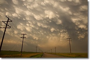
Weather Topic: What are Mammatus Clouds?
Home - Education - Cloud Types - Mammatus Clouds
 Next Topic: Nimbostratus Clouds
A mammatus cloud is a cloud with a unique feature which resembles
a web of pouches hanging along the base of the cloud.
In the United States, mammatus clouds tend to form in the warmer months, commonly
in the Midwest and eastern regions.
While they usually form at the bottom of a cumulonimbis cloud, they can also form
under altostratus, altocumulus, stratocumulus, and cirrus clouds. Mammatus clouds
warn that severe weather is close.
Next Topic: Nimbostratus Clouds
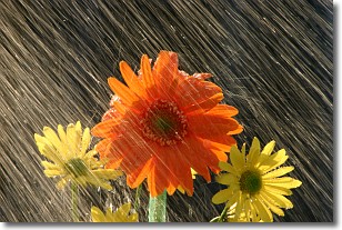
Weather Topic: What is Precipitation?
Home - Education - Precipitation - Precipitation
 Next Topic: Rain
Precipitation can refer to many different forms of water that
may fall from clouds. Precipitation occurs after a cloud has become saturated to
the point where its water particles are more dense than the air below the cloud.
In most cases, precipitation will reach the ground, but it is not uncommon for
precipitation to evaporate before it reaches the earth's surface.
When precipitation evaporates before it contacts the ground it is called Virga.
Graupel, hail, sleet, rain, drizzle, and snow are forms of precipitation, but fog
and mist are not considered precipitation because the water vapor which
constitutes them isn't dense enough to fall to the ground.
Next Topic: Rain
Current conditions powered by WeatherAPI.com


