Weather Alert in New York
Severe Thunderstorm Warning issued April 29 at 3:49PM EDT until April 29 at 4:45PM EDT by NWS Buffalo NY
AREAS AFFECTED: Genesee, NY; Livingston, NY; Monroe, NY; Ontario, NY; Wayne, NY
DESCRIPTION: SVRBUF The National Weather Service in Buffalo has issued a * Severe Thunderstorm Warning for... Southwestern Wayne County in western New York... Northern Livingston County in western New York... Southeastern Genesee County in western New York... Southeastern Monroe County in western New York... Northern Ontario County in western New York... * Until 445 PM EDT. * At 349 PM EDT, a severe thunderstorm was located over Pavilion, or 9 miles northwest of Geneseo, moving east at 50 mph. HAZARD...Ping pong ball size hail and 60 mph wind gusts. SOURCE...Radar indicated. IMPACT...People and animals outdoors will be injured. Expect hail damage to roofs, siding, windows, and vehicles. Expect wind damage to roofs, siding, and trees. * Locations impacted include... Honeoye Falls, Macedon, York, Canandaigua, Henrietta, Fishers, Livonia, Victor, Industry, and Gorham. This includes the following highways... Interstate 390 between exits 8 and 11. Interstate 90 between exits 43 and 46.
INSTRUCTION: Prepare immediately for large hail and damaging winds. People outside should move immediately to shelter inside a strong building. Stay away from windows.
Want more detail? Get the Complete 7 Day and Night Detailed Forecast!
Current U.S. National Radar--Current
The Current National Weather Radar is shown below with a UTC Time (subtract 5 hours from UTC to get Eastern Time).

National Weather Forecast--Current
The Current National Weather Forecast and National Weather Map are shown below.

National Weather Forecast for Tomorrow
Tomorrow National Weather Forecast and Tomorrow National Weather Map are show below.

North America Water Vapor (Moisture)
This map shows recent moisture content over North America. Bright and colored areas show high moisture (ie, clouds); brown indicates very little moisture present; black indicates no moisture.

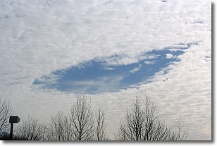
Weather Topic: What are Hole Punch Clouds?
Home - Education - Cloud Types - Hole Punch Clouds
 Next Topic: Mammatus Clouds
A hole punch cloud is an unusual occurrence when a disk-shaped
hole appears in a cirrostratus, cirrocumulus, or altocumulus cloud.
When part of the cloud forms ice crystals, water droplets in the surrounding area
of the cloud evaporate. The effect of this process produces a large elliptical
gap in the cloud. The hole punch cloud formation is rare, but it is not specific
to any geographic area.
Other names which have been used to describe this phenomena include fallstreak hole,
skypunch, and cloud hole.
Next Topic: Mammatus Clouds
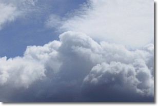
Weather Topic: What are Nimbostratus Clouds?
Home - Education - Cloud Types - Nimbostratus Clouds
 Next Topic: Precipitation
A nimbostratus cloud is similar to a stratus cloud in its formless,
smooth appearance. However, a nimbostratus cloud is darker than a stratus cloud,
because it is thicker.
Unlike a stratus cloud, a nimbostratus cloud typically brings with it the threat
of moderate to heavy precipitation. In some cases, the precipitation may evaporate
before reaching the ground, a phenomenon known as virga.
Next Topic: Precipitation
Current conditions powered by WeatherAPI.com


