Weather Alert in Ohio
Severe Thunderstorm Watch issued April 29 at 12:28PM EDT until April 29 at 7:00PM EDT by NWS Pittsburgh PA
AREAS AFFECTED: Belmont, OH; Carroll, OH; Columbiana, OH; Coshocton, OH; Guernsey, OH; Harrison, OH; Jefferson, OH; Monroe, OH; Muskingum, OH; Noble, OH; Tuscarawas, OH; Brooke, WV; Hancock, WV; Marshall, WV; Ohio, WV; Wetzel, WV
DESCRIPTION: THE NATIONAL WEATHER SERVICE HAS ISSUED SEVERE THUNDERSTORM WATCH 188 IN EFFECT UNTIL 7 PM EDT THIS EVENING FOR THE FOLLOWING AREAS IN OHIO THIS WATCH INCLUDES 11 COUNTIES IN EAST CENTRAL OHIO BELMONT CARROLL COLUMBIANA COSHOCTON GUERNSEY HARRISON JEFFERSON OH MONROE MUSKINGUM NOBLE TUSCARAWAS IN WEST VIRGINIA THIS WATCH INCLUDES 5 COUNTIES IN NORTHERN WEST VIRGINIA WETZEL IN THE NORTHERN PANHANDLE OF WEST VIRGINIA BROOKE HANCOCK MARSHALL OHIO THIS INCLUDES THE CITIES OF CADIZ, CALDWELL, CAMBRIDGE, CARROLLTON, COLUMBIANA, COSHOCTON, DOVER, EAST LIVERPOOL, FOLLANSBEE, MARTINS FERRY, MOUNDSVILLE, NEW MARTINSVILLE, NEW PHILADELPHIA, SALEM, ST. CLAIRSVILLE, STEUBENVILLE, WEIRTON, WELLSBURG, WHEELING, WOODSFIELD, AND ZANESVILLE.
INSTRUCTION: N/A
Want more detail? Get the Complete 7 Day and Night Detailed Forecast!
Current U.S. National Radar--Current
The Current National Weather Radar is shown below with a UTC Time (subtract 5 hours from UTC to get Eastern Time).

National Weather Forecast--Current
The Current National Weather Forecast and National Weather Map are shown below.

National Weather Forecast for Tomorrow
Tomorrow National Weather Forecast and Tomorrow National Weather Map are show below.

North America Water Vapor (Moisture)
This map shows recent moisture content over North America. Bright and colored areas show high moisture (ie, clouds); brown indicates very little moisture present; black indicates no moisture.

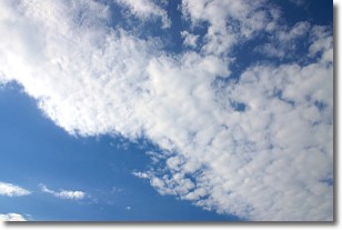
Weather Topic: What are Stratus Clouds?
Home - Education - Cloud Types - Stratus Clouds
 Next Topic: Wall Clouds
Stratus clouds are similar to altostratus clouds, but form at a
lower altitude and are identified by their fog-like appearance, lacking the
distinguishing features of most clouds.
Stratus clouds are wider than most clouds, and their base has a smooth, uniform
look which is lighter in color than a nimbostratus cloud.
The presence of a stratus cloud indicates the possibility of minor precipitation,
such as drizzle, but heavier precipitation does not typically arrive in the form
of a stratus cloud.
Next Topic: Wall Clouds
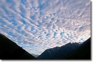
Weather Topic: What are Altocumulus Clouds?
Home - Education - Cloud Types - Altocumulus Clouds
 Next Topic: Altostratus Clouds
Similar to cirrocumulus clouds, altocumulus clouds are
characterized by cloud patches. They are distinguished by larger cloudlets
than cirrocumulus clouds but are still smaller than stratocumulus clouds.
Altocumulus clouds most commonly form in middle altitudes (between 2 and 5 km)
and may resemble, at times, the shape of a flying saucer.
These uncommon formations, called altocumulus lenticularis, are created by uplift
in the atmosphere and are most often seen in close proximity to mountains.
Next Topic: Altostratus Clouds
Current conditions powered by WeatherAPI.com


