Weather Alert in Texas
Flood Warning issued April 29 at 8:14AM CDT by NWS Norman OK
AREAS AFFECTED: Wichita, TX; Wilbarger, TX
DESCRIPTION: ...The National Weather Service in Norman OK has issued a Flood Warning for the following rivers in Texas... Beaver Creek near Electra affecting Wilbarger and Wichita Counties. * WHAT...Major flooding is forecast. * WHERE...Beaver Creek near Electra. * WHEN...From late tonight until further notice. * IMPACTS...At 29.0 feet, Widespread flood levels up to 5 feet in depth cover farm and range lands... and may inundate some oil and gas facilities... along and near the creek in southern Wilbarger County and southwestern Wichita County. * ADDITIONAL DETAILS... - At 8:00 AM CDT Tuesday the stage was 13.5 feet. - Bankfull stage is 24.0 feet. - Forecast...The river will rise above flood stage late tonight to 28.9 feet early Thursday morning. It will then fall Thursday morning. It will rise to 29.0 feet early Thursday afternoon. It will then fall below flood stage early Friday afternoon to 23.3 feet Friday evening. It will then rise above flood stage again early Saturday morning. - Flood stage is 24.0 feet. - Flood History...This crest compares to a previous crest of 29.0 feet on 04/20/1990. - http://www.weather.gov/safety/flood
INSTRUCTION: Turn around, don't drown when encountering flooded roads. Most flood deaths occur in vehicles. Additional information is available at www.weather.gov.
Want more detail? Get the Complete 7 Day and Night Detailed Forecast!
Current U.S. National Radar--Current
The Current National Weather Radar is shown below with a UTC Time (subtract 5 hours from UTC to get Eastern Time).

National Weather Forecast--Current
The Current National Weather Forecast and National Weather Map are shown below.

National Weather Forecast for Tomorrow
Tomorrow National Weather Forecast and Tomorrow National Weather Map are show below.

North America Water Vapor (Moisture)
This map shows recent moisture content over North America. Bright and colored areas show high moisture (ie, clouds); brown indicates very little moisture present; black indicates no moisture.

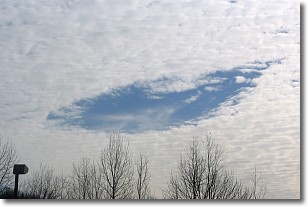
Weather Topic: What are Hole Punch Clouds?
Home - Education - Cloud Types - Hole Punch Clouds
 Next Topic: Mammatus Clouds
A hole punch cloud is an unusual occurrence when a disk-shaped
hole appears in a cirrostratus, cirrocumulus, or altocumulus cloud.
When part of the cloud forms ice crystals, water droplets in the surrounding area
of the cloud evaporate. The effect of this process produces a large elliptical
gap in the cloud. The hole punch cloud formation is rare, but it is not specific
to any geographic area.
Other names which have been used to describe this phenomena include fallstreak hole,
skypunch, and cloud hole.
Next Topic: Mammatus Clouds
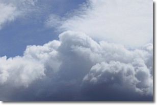
Weather Topic: What are Nimbostratus Clouds?
Home - Education - Cloud Types - Nimbostratus Clouds
 Next Topic: Precipitation
A nimbostratus cloud is similar to a stratus cloud in its formless,
smooth appearance. However, a nimbostratus cloud is darker than a stratus cloud,
because it is thicker.
Unlike a stratus cloud, a nimbostratus cloud typically brings with it the threat
of moderate to heavy precipitation. In some cases, the precipitation may evaporate
before reaching the ground, a phenomenon known as virga.
Next Topic: Precipitation
Current conditions powered by WeatherAPI.com


